Scroll down to view the summary report for each stage of the Anglesea Coastal Adaptation Plan
Stages will be added here as they are completed. Be sure to click the +Follow button at the top of the page to subscribe for project updates.
Introduction
The Anglesea Coastal Adaptation Plan (CAP) is being developed by the Great Ocean Road Coast and Parks Authority (GORCAPA, referred herein as The Authority) with support from the Department of Energy, Environment and Climate Action (DEECA), following the Victoria’s Resilient Coast – Adapting for 2100+ framework (VRC Guidelines).
The scope of the Anglesea CAP is to develop a local adaptation plan for the Anglesea township coastline. This involves planning for current and future coastal hazards, including sea level rise.
The VRC Guidelines set out a seven-stage process for coastal hazard adaptation in Victoria. This process supports place-based, best practice, long-term coastal hazard risk management and adaptation to support planning and strategic decision making.
Wadawurrung Traditional Owner knowledge, rights and assertions; partnerships and a collaborative process; as well as engagement and communication are embedded into every stage.
VRC Framework Stages
The VRC Guidelines build on the directions of the Marine and Coastal Act 2018 and Marine and Coastal Policy 2020. The seven stages of the process for coastal hazard adaptation are outlined in graphic below:
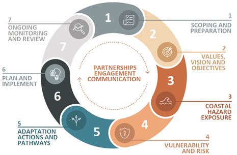
Above: The Victoria's Resilient Coast – Adapting for 2100+ framework and guidelines (DEECA, 2023) outline a seven-stage process to coastal hazard risk management and adaptation planning.
Hazards Explained
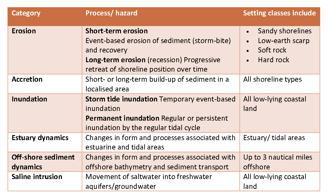
Victoria has over 2,600 km of coastline, including extensive sandy beach systems, rocky coasts, bays, inlets and estuaries, coastal lakes and floodplains. These diverse cultural landscapes have been nurtured by Traditional Owners of Country for countless generations, and are dynamic environments shaped by coastal processes. Coastlines are among the most dynamic regions on the planet, and Victoria’s coastline is constantly undergoing change, often at rapid rates. At times, natural coastal processes including erosion, inundation and other physical/chemical processes may have an adverse impact on coastal values and uses. When this occurs, we often refer to these processes as coastal hazards.
Erosion and inundation are examples of natural coastal processes that have shaped the coastline we see and enjoy today. When natural processes impact on values, such as how we access or enjoy the coast, we refer to them as coastal hazards.
Adaptation Explained
Adaptation is the process of adjustment to actual or expected climate change and its impacts.
A pathways approach to adaptation enables a range of actions to be identified to reduce current and emerging coastal hazard risk. Adaptation pathways set out the relative sequence, timing and triggers for different actions. The Marine and Coastal Policy 2020 guides the order in which adaptation options are considered, as follows.
1. Non-Intervention
Allowing marine and coastal processes to occur without intervention can be appropriate in certain situations. This approach may be chosen when the risk from hazards is manageable, when intervention could lead to negative consequences, or when it would be ineffective or too costly.
2. Avoid
Locate new uses, development and redevelopment away from areas that are or will be negatively impacted by coastal hazards. This also needs to consider the type of use or development and if it is appropriate for the location. Avoidance can also help natural systems adapt by avoiding development where it would impede the movement of habitats and species, or decrease their resilience to the effects of climate change.
3. Nature-based Methods
Enhancing the resilience of both existing and new developments against coastal hazards can be achieved by restoring natural features. For example, restoring native vegetation can reduce erosion on dune systems. Additionally, preserving migration corridors allows habitats and species to adapt landward as conditions change. Nature-based approaches offer multiple benefits, as they not only improve resilience and biodiversity in coastal ecosystems but also enhance community amenities.
4. Accommodate
Structures can be designed to reduce the exposure to, or decrease the impact of, coastal hazard risk, thus ‘accommodating’ the risk. Examples of this could include building lifesaving towers that can be rapidly and easily moved to respond to an eroding shoreline or using building design techniques that reduce the impact of flooding. Accommodate options can be useful to improve resilience and ‘buy more time’ before further actions are necessary.
5. Retreat
Existing structures and uses may need to be decommissioned or relocated from areas at risk of coastal hazards. Planning for the timing of this retreat should be proactive and site-specific, ensuring that relocated structures are not moved to areas with other hazards.
6. Protect
Existing physical barriers are enhanced, or new ones constructed, to mitigate the impact of coastal hazards caused by marine and coastal processes. An example would be the enhancement or construction of sea walls to protect strategically important values from sea-level rise and storm surge. Protect is an option of last resort; it is often expensive, its benefits tend to be very localised, and it frequently transfers the problem to nearby areas. Despite the inherent problems, a point in time will be reached for many areas with existing development where either retreat or protect options will be the most effective and appropriate adaptation action. The timing of these actions will differ across Victoria.
After working through this hierarchy of considerations, an adaptation pathway is developed in order to plan how to put each treatment option into action over time. To do this, various triggers are put in place that let us know when to move from one to the next. Triggers can include:
Each section of the coast is unique and requires a unique response to hazards, therefore each adaptation plan is different and bespoke to each site. An example adaptation pathway with adaptation options for various sections of coast is shown below.
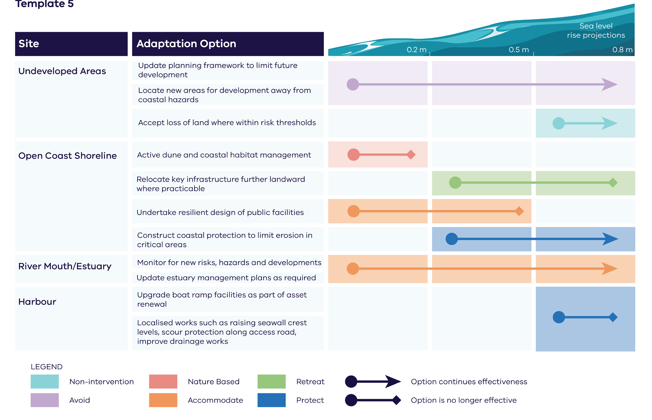
Above: Example of adaptation pathways for different sections of coast (source: BMT).
1.1 Stage Purpose
The purpose of Stage 1 is to provide a foundation for commencing coastal hazard risk management and adaptation planning, aligned to best practice guidance, in this case at the Anglesea local context. This stage sets the process of adaptation informed decision-making in subsequent stages of coastal adaptation planning.
Stage 1 has progressed the holistic understanding of the coastal hazards and associated potential risks facing Anglesea’s coastline in the context of ongoing climate change, sea level rise, population growth and development. The work completed in this stage is critical for developing targeted and effective adaptation strategies in later stages, aiming to enable The Authority, DEECA and local stakeholders to plan for a more resilient future. A key outcome of this stage is identifying the requirements and gaps in data and information for subsequent stages of the Anglesea CAP.
Noting that Stage 2 “Values, vision and objectives” of the Anglesea CAP was progressed in parallel to Stage 1, the work conducted in Stage 1 focused on identifying the coastal compartments within the study area and detailing the studies and investigations required to complete Stage 3 “Coastal hazard exposure” and Stage 4 “Vulnerability and risk”, and outlining the work for Stage 5 “Adaptation actions and pathways”.
1.2 The Need For Action
The Anglesea coastline is a stunning and ever-changing part of our landscape, shaped by natural forces like winds, waves, tides, and currents. Wadawurrung Traditional Owners have cared for this coastal area for countless generations. This coastline and marine environment hold a wide range of values and features significant to both local communities and visitors, including:
Environmental: biodiversity, landscapes, marine protected areas, natural coastal processes
Social: community identity and diversity, recreation, well-being
Cultural: Indigenous (Wadawurrung) heritage, cultural practices, historical importance
Economic: tourism, aquatic and fishing activities, property and real estate
The coastline of Anglesea is valued for its biodiversity, landscape, recreational opportunities, cultural significance to Wadawurrung People, and its contribution to the local economy through tourism and other activities. Coastal erosion and storm tide inundation are considered natural processes and shape the coastline. When these processes impact on those values and features we care about, be it environmental, cultural heritage or social or economic, these are referred to as coastal hazards.
Coastal hazards are directly impacting a range of coastal values around Anglesea, and these impacts are expected to increase over time. Rapid erosion of popular beaches, e.g., Point Roadknight and the soft-rock cliffs at Soapy Rock and Demon’s Bluff, coastal inundation and drainage issues, ageing coastal protection infrastructure and sensitive coastal ecosystems are all examples of existing safety and coastal management conflicts and challenges. Climate change and sea level rise are projected to likely exacerbate these and other issues. Hence, a long-term plan for action is needed to respond to current issues and increase coastal resilience into the future.
The Authority’s Coastal and Marine Management Plan (CMMP) 2020 – 2025 identified the following three sites within the study area as priority adaptation locations:
All of these sites are anticipated to require an adaptation response within the next 10 to 20 years.
The Anglesea CAP provides an opportunity to bring together the range of information relevant to coastal hazard resilience in Anglesea to support consistent and considered planning and decision making. The Anglesea CAP will enable place-based, best practice and long-term coastal hazard risk management and adaptation.
1.3 Study Area
Located along the Great Ocean Road within Wadawurrung Country approximately 115 km south-west of Melbourne, the township of Anglesea and its surrounding coastline are exposed to coastal hazards including short and long-term erosion, storm tide inundation and estuary dynamics. Much of this vulnerable area is coastal Crown land.
Environment Setting
The marine and coastal environment of Anglesea encompasses rich and diverse ecosystems, featuring a mix of sandy beaches, rocky headlands, intertidal zones, and estuarine areas. Located along the famous Great Ocean Road, this coastal zone is shaped by the powerful forces of the Southern Ocean and is home to a variety of marine and coastal species. It is also a popular destination for outdoor activities such as surfing, fishing, and hiking.
Coastal Environment
Beaches and Sand Dunes:
The coastline around Anglesea includes broad, sandy beaches, like Anglesea Beach and Point Roadknight Beach. These beaches are composed of fine to medium grain sand backed by vegetated dunes. The sand dunes are crucial for sand storage and buffering the adjacent land areas from erosion, and protecting inland areas from storm surges and high tides.
The dune systems are often stabilized by coastal vegetation, including species such as marram grass and coastal scrub, which help build dune forms and limit erosion caused by wind and wave action.
Cliffs and Rocky Headlands:
Erosion of sedimentary rocks, such as sandstone and limestone, has formed dramatic cliffs and headlands in the area, especially around Demon’s Bluff, Soapy Rocks and Point Roadknight. These rocky formations are subject to ongoing erosion by waves, creating unique shapes and adding to the dynamic landscape.
The cliffs and intertidal platforms provide habitat for many species of seabirds, as well as invertebrates and algae that live in the rocky crevices.
Estuaries and Wetlands:
The Anglesea River estuary is an important feature of the coastal environment. It supports brackish water habitats where freshwater from the river mixes with seawater. The estuary is home to a variety of bird species, fish, and invertebrates, and serves as a breeding ground for many aquatic species.
Wetlands near the estuary provide valuable habitat for migratory birds and contribute to water purification and flood mitigation.
Coastal Moonah Woodland:
There is significant Coastal Moonah Woodland located at Point Roadknight which is listed as a threatened community under the Flora and Fauna Guarantee Act 1998. Coastal Moonah Woodland is in a “demonstrable state of decline which is likely to result in extinction” (Vic Gov, 1998). In accordance with the Authority’s vision and mission, it is imperative to enhance this natural asset through carefully considered and appropriate threat control actions.
Marine Environment
Rocky Reefs and Intertidal Zones:
The shallow rocky reefs in the nearshore waters of Anglesea provide a complex habitat for marine life. These reefs are often covered in seaweed forests, primarily composed of kelp and other algae, which create rich habitats for fish, molluscs, and invertebrates.
The intertidal zone is a dynamic area where organisms must adapt to both marine and terrestrial conditions, with species such as barnacles, mussels, crabs, and sea snails thriving in this zone.
Marine Fauna:
The waters off Anglesea are home to a wide range of marine species, including fish like snapper, Australian salmon, and gummy sharks, as well as various rays. Dolphins are occasionally seen in the area, and seals may be spotted near rocky outcrops or further offshore.
The area also supports a variety of bird species, such as cormorants, seagulls, and pelicans, that rely on both the marine and coastal environments for feeding.
Protected Marine Areas:
Point Addis Marine National Park, located to the southwest of Anglesea, protects over 4,600 hectares of coastal and marine environment. It preserves important habitats such as underwater reefs, seagrass beds, and sponge gardens, supporting biodiversity and sustaining healthy fish populations.
This marine park also safeguards species like the weedy seadragon, an iconic species of the region, and various types of corals and sponges that thrive in the cool, nutrient-rich waters
Geomorphological Setting
The coastal geomorphology of Anglesea is characterized by a diverse range of landforms shaped by the interplay of marine and terrestrial processes. The region’s landscape is defined by cliffs, sandy beaches, dunes, and estuarine features, all influenced by the Southern Ocean’s strong wave action and wind patterns.
Key Features
1. Cliffs and Headlands: The coastline near Anglesea includes rugged cliffs formed from sedimentary rock layers like sandstone and limestone. These cliffs have been eroded over time by wave action, forming steep escarpments and rocky outcrops, especially prominent around Demon’s Bluff and Point Roadknight.
2. Beaches: Anglesea has wide sandy beaches, with Anglesea Beach and Point Roadknight Beach being the most notable. These beaches are formed from sediments eroded from nearby cliffs and carried by longshore drift.
3. Dunes: Behind the beaches, there are sand dunes that are shaped by wind and stabilized by vegetation. These dunes provide a buffer between the land and sea and are important for coastal protection.
4. Estuarine System: The Anglesea River estuary plays a significant role in the local geomorphology, where the river meets the ocean. The estuary’s dynamics influence the sediment deposition patterns in the area, particularly near the river mouth.
5. Tidal Flats and Reefs: Rocky reefs and intertidal platforms are common along the coastline, providing habitat for marine life and influencing coastal erosion patterns.
The coastal geology and geomorphology of the area is highly variable, with the combination of these features resulting in a dynamic coastal environment shaped by natural forces such as erosion, sediment deposition, and wave energy. The geomorphological setting influences how the coastline responds to coastal processes, habitat types, historical development patterns, and cultural values, in particular the way the coastline has been and may be used and accessed by the community. Conversely, human activities, including tourism and development, also affect the geomorphology, especially with management of the dunes and estuary.
General Management Arrangements of the Study Area
The coastal area of Anglesea, Victoria, is managed through a combination of local, state, and commonwealth government funded bodies, as well as community organizations, with interest in protection and sustainable use and development of its natural resources. In general, management seeks to balance environmental conservation with recreational, cultural, and economic activities. Key aspects of management of the Anglesea coastal and marine environment involve the protection of natural habitats, addressing coastal hazards such as erosion, maintaining public access, and ensuring the sustainability of marine and coastal ecosystems.
Key Management Bodies
1. Great Ocean Road Coast and Parks Authority (GORCAPA – “The Authority”)
2. Department of Energy, Environment and Climate Action (DEECA)
3. Surf Coast Shire Council (SCSC)
4. Parks Victoria (PV)
5. Wadawurrung Traditional Owners Aboriginal Corporation (WTOAC) is the Registered Aboriginal Party (RAP)
Further engagement with existing community networks to enhance community resilience in adaptation planning will be undertaken throughout the Anglesea CAP process. By building on established networks of local emergency services, community organisations, and government agencies, adaptation strategies can be more effectively integrated into emergency response plans.
Coastal Compartments for Adaptation Planning
The Anglesea CAP study area (see Figure 3) extends from O’Donohues Beach north to Grinders Point and covers the coastline fringing the broader Anglesea township area as well as the estuarine portion of the Anglesea River. The inland extent of the study area will be further informed as the project progresses and the extent of coastal hazards is better understood.
The VRC Guidelines direct coastal adaptation planning to consider marine and coastal processes in the context of ‘coastal compartments’, delineated based on landforms and sediment transport processes. Following this guideline, coastal compartments were identified in Stage 1 with consideration of the coastal processes, geomorphological setting, habitat types, historical development patterns, social values, and in particular the way the coastline has been and may be used and accessed by the community. The coastal compartments delineated for the Anglesea CAP are illustrated in Figure 4 and described in Table 2.
The Anglesea River estuary compartments are included in the Anglesea CAP scope and will be progressed through stages 4-5 using current existing data and information. Noting that a Flood Hazard and Risk Assessment will be undertaken for the Anglesea River (led by other agencies), in the near future (completion expected within 2-3 years). The Anglesea CAP will be reviewed and updated to integrate the outcomes of such flood assessment. This is likely to occur in a future revision of the Anglesea CAP and shall be noted in the adaptation pathways for those river and estuary compartments.
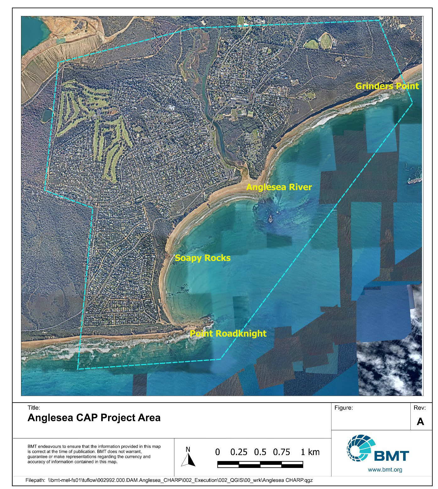
Above - Anglesea CAP Study Area
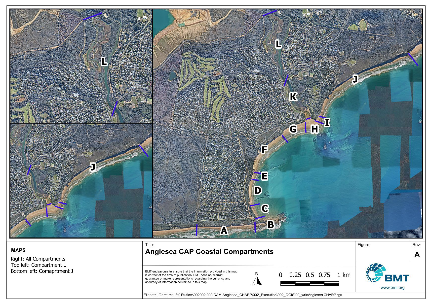
Above - Anglesea CAP Adaptation Planning Compartments
1.4 State, Regional and Local Context
At the state level, coastal adaptation in Anglesea falls under the legislation of Victoria’s Climate Change Act 2017 and Marine and Coastal Act 2018, statewide Marine and Coastal Policy 2020 and the Marine and Coastal Strategy 2022. These policy and strategy provide a framework for addressing the impacts of climate change, including sea-level rise, coastal hazards and associated risks. The state government, through the Department of Energy, Environment and Climate Action (DEECA) and Parks Victoria, oversees the implementation of strategies to protect natural assets, infrastructure, and communities. The "Victoria’s Resilient Coast – Adapting for 2100+" Guidelines offer long-term planning tools and risk assessments to manage climate risks, emphasizing the protection of vulnerable coastal and marine ecosystems and associated values while preparing for future challenges.
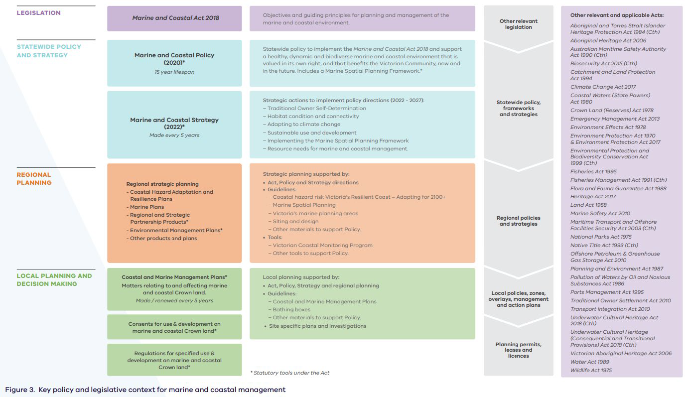
Above – Policy and legislation context - Victoria’s Resilient Coast – Adapting for 2100+
Regional Context:
As part of the broader Great Ocean Road Region, which is a major tourism destination, the region faces increased pressures from visitor growth, development, and the impacts of climate change and coastal hazards. The Authority (GORCAPA) works closely with the local Councils, such as Surf Coast Shire Council and other stakeholders to implement adaptation strategies, balancing the need for environmental protection with tourism and recreational use. Regionally, adaptation efforts focus on preserving biodiversity, managing erosion along sandy beaches and dunes, and safeguarding critical infrastructure, such as roads and coastal facilities, from the effects of climate change.
Local Context:
Locally, Anglesea’s coastal adaptation efforts are driven by community engagement, local land-use planning, and involvement of the Traditional Owners—Wadawurrung people.
The Anglesea CAP has received funding through Victoria's Resilient Coast, Round One Grants Program and is the first township-scale Coastal Adaptation Plan (CAP) undertaken by the Authority. It will align with and potentially inform other essential initiatives, such as:
2.1 Stage Purpose
The purpose of this stage is to underpin coastal hazard risk management and adaptation planning by place-based values and a shared vision and objectives. This includes Traditional Owner knowledge, rights and assertions, the Victorian Marine and Coastal Policy 2020 vision, and aspirations of stakeholders, including community.
A focus of Stage 2 for the Anglesea CAP was on progressing engagement and communication of the adaptation process with the community, Wadawurrung People and stakeholders. This early engagement involved collating input into a shared vision and objectives for adaptation planning.
2.2 Approach
The approach followed was collaborative, with open communication and engagement. While there are many steps involved in coastal hazard adaptation planning, understanding local knowledge and values of our coastline is at the heart of the process. This is why the work in this stage aimed at gathering input and confirming local aspirations and values, providing a strong foundation for strategic coastal hazard risk management and adaptation; ultimately informing the scope of work in future stages.
The Anglesea coastline is Wadawurrung Country. Our approach to Traditional Owner engagement for the Anglesea CAP is proactive, with introduction of the goals of the plan to WTOAC from inception of this project and their involvement through Stage 2 and going forward. Further detail of this is outlined in the Engagement Plan.
The community engagement summary report documents the approach implemented, and is summarised below:
Our engagement process Love of the Anglesea Coast was conducted from February to March 2024 to explore and further understand community knowledge and values of our coastline, which are at the heart of the coastal adaptation planning process.
The engagement started when the summer holidays were over in mid-February so we could engage more efficiently with the local community, stakeholders and schools, and concluded in late March to allow for engagement over the March long weekend.
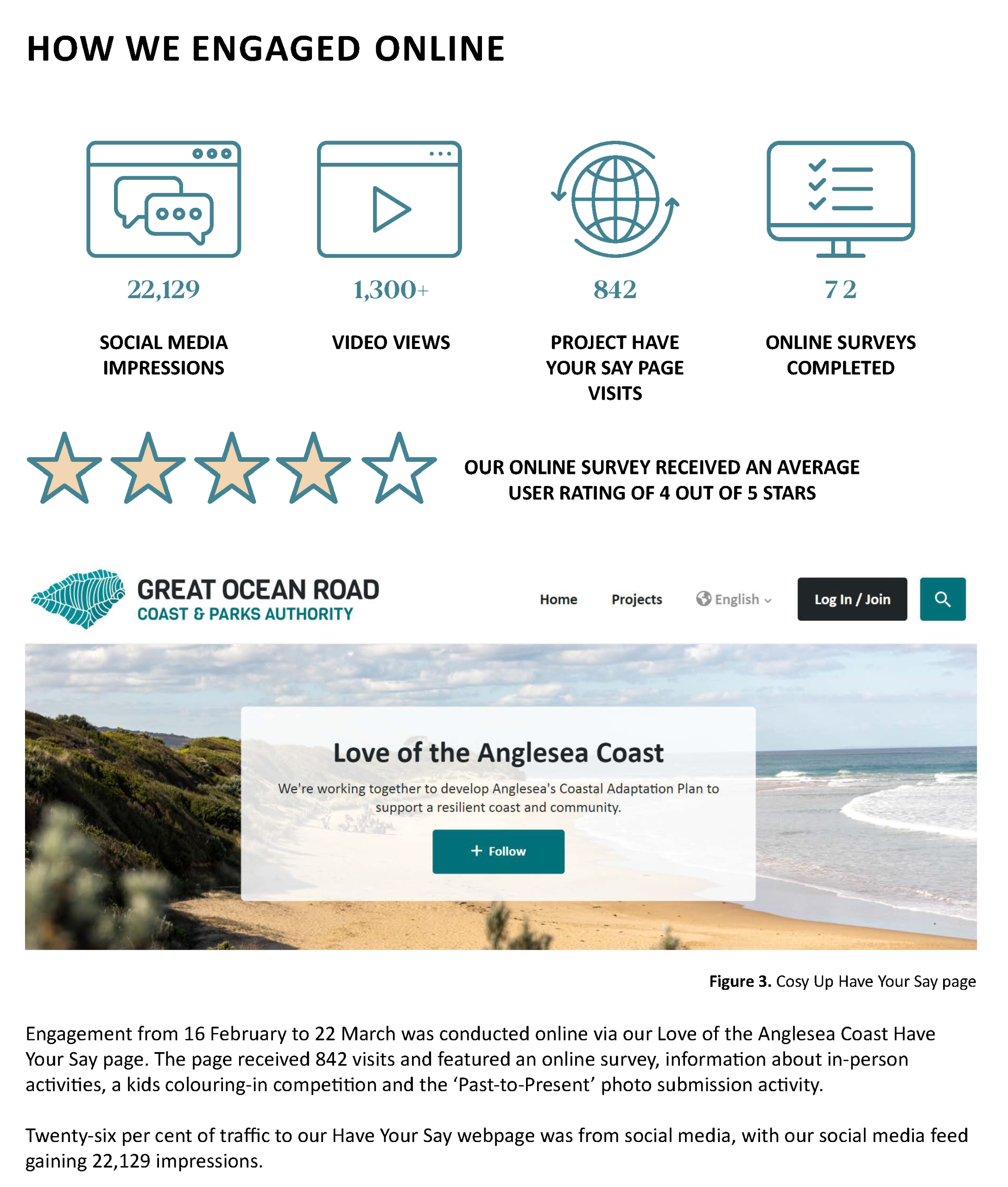
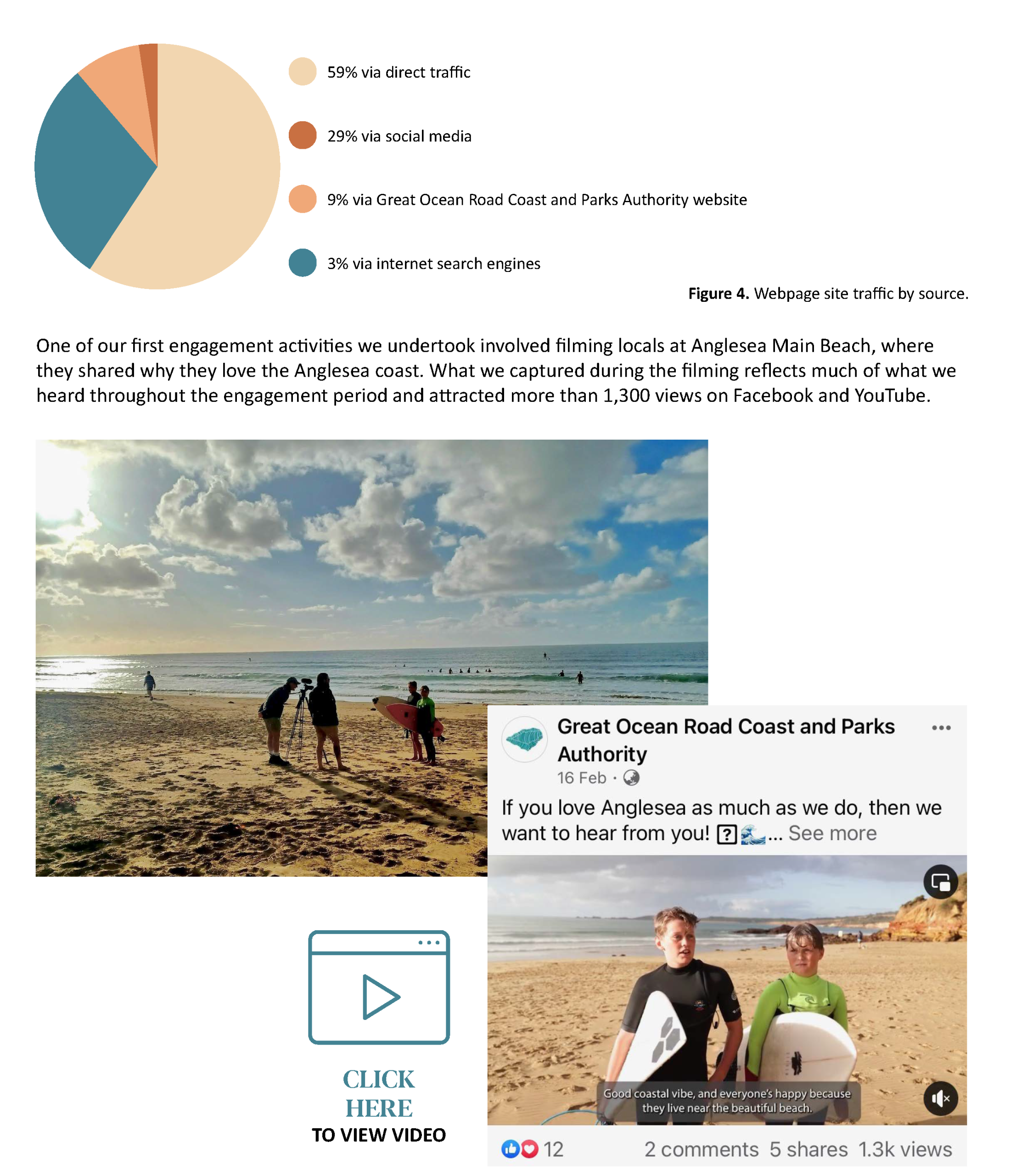
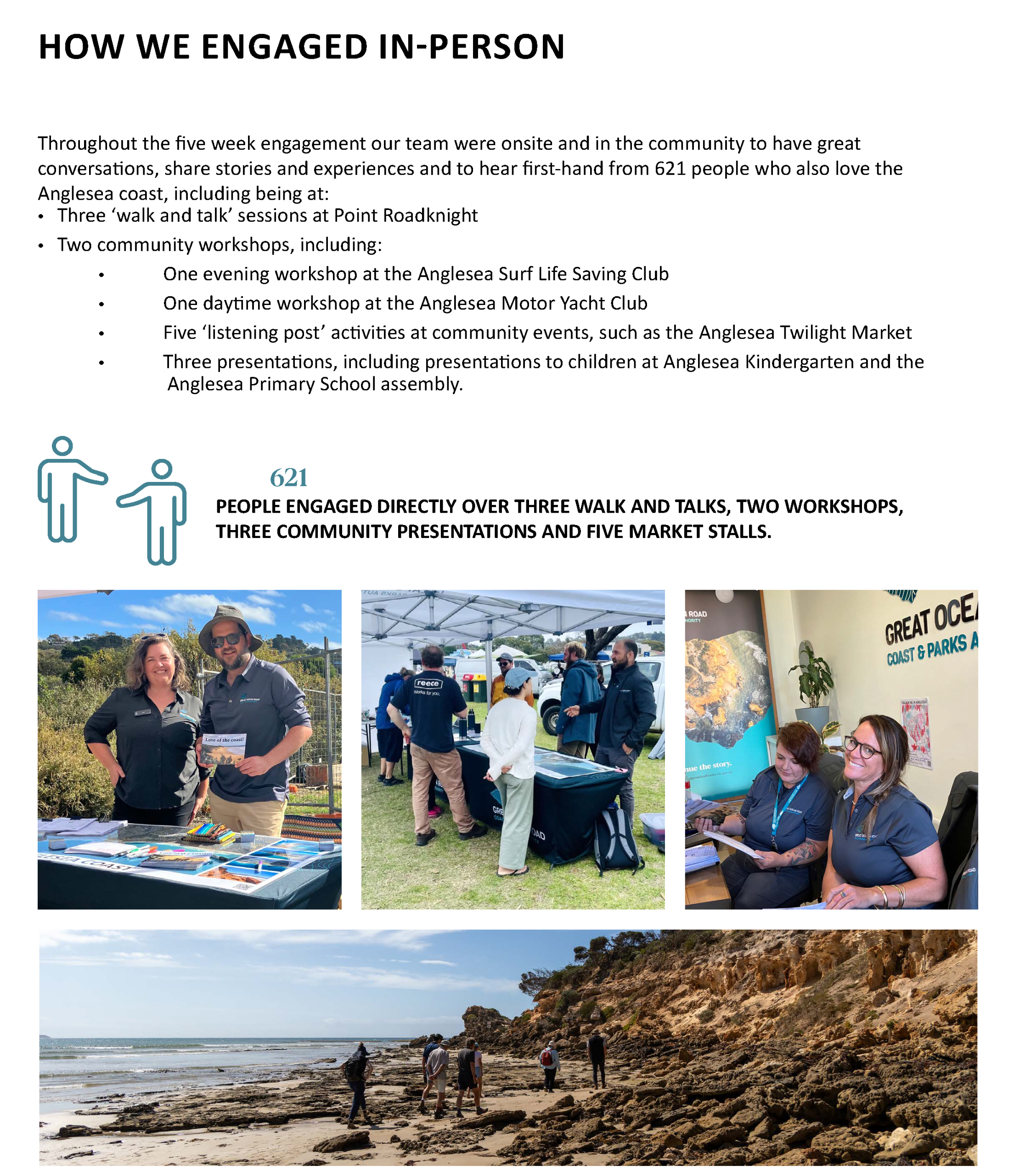
Our engagement featured in-person activities, online components including a 28-question survey hosted on our Have Your Say page, and also a strong community focus in recognition of the wonderful community networks and groups that exist in Anglesea.
The design of our engagement focused on capturing community values and aspirations along this unique and highly valued section of coast, and hearing from community about their knowledge of coastal hazards and wiliness for adaptation on the Anglesea coast.
We did this because we understand that community values, knowledge and aspirations provide a strong foundation for strategic coastal hazard risk management and adaptation and directly inform the decision making, actions and priorities at future stages of this project and scope of future works.
We integrated community values into our engagement by asking:
We checked in on local knowledge of coastal hazards and the perceived need for coastal adaptation, by asking those we engaged with to:
We sought to understand community aspirations and priorities for the future of the Anglesea coast by asking:
2.3 Values Summary
Cultural Heritage
The coast of Anglesea holds significant cultural heritage for Wadawurrung people, the Traditional Owners of the land. The coastline contains important cultural sites such as middens, scarred trees, and other archaeological remains that offer a deep connection to Aboriginal history and traditions. These sites reflect thousands of years of Wadawurrung cultural practices, including the sustainable use of coastal resources for food and shelter. The area’s cultural heritage also includes European settlement history, with the development of the Great Ocean Road and its role in shaping the region's identity. Protecting these cultural values needs to be considered in coastal management and adaptation planning, ensuring the preservation of both Indigenous and historical heritage for future generations.
Community
The Anglesea coastline is a central part of the local community’s identity and lifestyle. It provides a place for recreation, leisure, and social interaction through activities such as beach walking, swimming, surfing, boating nature exploration. The community is actively engaged in conservation efforts, with local volunteer groups, such as Anglesea Community Network, Coastcare and Friends of the Anglesea Coast and River, playing a role in protecting and restoring coastal environments. The coastline fosters a strong sense of belonging and environmental stewardship, with residents valuing the natural beauty and health of their coastal environment. Community involvement in local coastal management and adaptation planning ensures that decisions reflect the needs and values of Anglesea’s community of locals and visitors.
Environmental
The Anglesea coast is rich in environmental values, with diverse ecosystems including sandy beaches, rocky reefs, estuaries, vegetated dunes and significant Coastal Moonah Woodland. These habitats support a wide variety of native flora and fauna, including seabirds, marine invertebrates, and species such as the weedy seadragon. The Point Addis Marine National Park, located nearby, protects underwater ecosystems and biodiversity, providing a haven for marine life. Environmental values are also linked to natural processes like coastal erosion control, sediment transport, and water filtration, which are essential for maintaining the health of the coastline. Protecting these ecosystems, through the process of adaptation planning for the impacts of climate change and human activity is crucial for ensuring the long-term sustainability of the coastal environment.
Economic
The economic value of Anglesea’s coast is driven primarily by tourism and recreational activities. As part of the iconic Great Ocean Road region, the coastline attracts visitors for its natural beauty, beaches, and outdoor experiences, contributing to the local economy through businesses such as accommodation, retail, hospitality, and tourism services. Fishing (both recreational and small-scale commercial) also supports the local economy. In addition, the high demand for coastal property in Anglesea increases real estate values, with the natural environment being a key attraction for homeowners and investors. Sustainable management of the coast requires appropriate planning and adaptation to coastal hazard risks for the continued economic benefits while balancing environmental and cultural preservation.
2.4 Shared Values, Vision and Objectives
Values
Vision
A healthy and resilient Anglesea coast, ready adapt to coastal changes, so it can be accessed and enjoyed by current and future generations.
Objectives
Stage 3 is currently in progress. We anticipate having the stage complete and the summary report available here in the first half of 2026.
Contact Us
If you have any feedback, questions, or concerns or just want to learn more about a project, please contact us below:
| haveyoursay@greatoceanroadauthority.vic.gov.au |


