Point Grey is on the lands of the Gadubanud People, part of Eastern Maar Nation, which has a rich cultural heritage and a wealth of environmental values.
Current Status
Redevelopment of the Point Grey Precinct has taken a huge step forward, with planning and design nearing completion.
The engagement period is now closed as we prepare for construction to commence in early 2026.
Explore project and engagement materials below!
Project Overview
The Point Grey Redevelopment is one of our highest priorities, and we are keenly aware of the strong community support to see this project succeed.
Redeveloping Point Grey will create a unique experience for local residents and visitors, which will benefit the local economy and the Lorne and Surf Coast Shire community.
The redevelopment will provide new and improved facilities onsite including;
- a new Lorne Aquatic and Angling Club
- improved connectivity between the water’s edge and the public space with upgraded walking paths within the project area
- recognition of cultural heritage
- space for casual hospitality offerings, including options for coffee, takeaway and al fresco seating.
The Geelong City Deal is providing $10.14 million, the Authority is contributing $2 million and the Lorne Aquatic and Angling Club is providing $450,000, bringing the total project budget to $12.59 million.
This project is being delivered as part of the $676.15 million Geelong City Deal, a collaborative partnership to transform Geelong and the Great Ocean Road by the Australian Government and Victorian Government, and local council with the Authority and key partners.
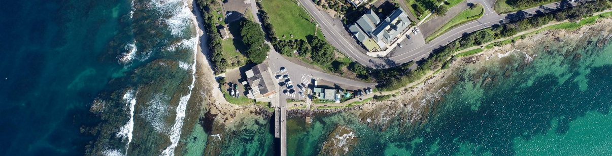
The Point Grey Precinct (the Precinct) is an area of public land on the Lorne foreshore, located at the eastern-most point of Lorne, to the south of the town centre. The Precinct is connected to the centre of Lorne by a walking track along the foreshore and is the starting point for the annual Lorne ‘Pier to Pub’ swimming event. It is also the site of the Port of Lorne and comprises a mix of public assets, including, among other things:
- Lorne Pier
- Former Fishing Co-op Building
- Lorne Angling and Aquatic Club (LAAC) building
- New beach access, boat ramp
- Historic boat ramp (pedestrian only ‘Pier to Pub’ ramp)
- Public open space reserve, including barbeque, picnic tables, passive recreation area.
- Public toilets
- Public lighting
- Car parking
- Mature trees and landscaping
In addition to its Indigenous cultural heritage significance, the Precinct is an integral part of the Lorne community, valued for its economic, environmental, social, and cultural importance. It is widely used by locals, holidaymakers, and day visitors alike.
Since the previous redevelopment application, the legislative and policy context has shifted significantly. The focus is now firmly on protecting coastal habitats and the natural environment, ensuring resilience for maritime recreation and infrastructure, and safeguarding ports from climate change impacts, among other things. Policy has moved away from promoting coastal Crown land for general tourism revenue, toward supporting only coastal-dependent recreational and eco-tourism activities that enhance the coast’s natural and cultural values.
In line with the Marine and Coastal Policy 2020, the Authority is committed to minimising the building footprint at the site, while ensuring the site can still support appropriate coastally dependent uses. These include passive and active maritime recreation, in line with the purpose of the Public Parks and Recreation Zone, as well as the protection of the coastline, consistent with the land’s reservation under the Crown Land Reserves Act 1978.
The Great Ocean Road and Environs Protection Act 2020
Pursuant to the Great Ocean Road and Environs Protection Act 2020, the Authority must apply the Great Ocean Road Coast and Parks Protection Principles when carrying out any function, duty, or power related to land under its management, including the development of the Point Grey UDF and the precinct’s future redevelopment.
These Principles fall under four categories:
- General and Economic
- Aboriginal Inclusion
- Environmental
- Social
Decisions must reflect a careful balance and integration of environmental, cultural, social, and economic values.
The Crown Land (Reserves) Act 1978
The Point Grey precinct is reserved under the Crown Land (Reserves) Act 1978 for the “protection of the coastline” for the benefit of all Victorians.
P1182/2020 Victorian Civil and Administrative Tribunal Determination
The previous iteration of the Point Grey redevelopment, which required a planning permit, received a Notice of Decision to Grant a Permit from Surf Coast Shire. This decision was appealed by members of the Lorne community, with the Lorne Aquatic and Angling Club joining the appeal. The matter was heard at Victorian Civil and Administrative Tribunal (VCAT), which ultimately overturned the decision in 2022.
A copy of the VCAT determination order can be found, here.
Pertinent grounds for refusal made in the determination order included:
- 188. This proposal is essentially for a Restaurant in this location to attract tourism revenue, as opposed to providing support to the marine and coastal location and anticipated activities within it.
- 189. The Restaurant is not dependent on the coastal location and Point Grey does not require a Restaurant, nor is this use naturally aligned with the purposes of the Public Park and Recreation Zone (PPRZ), or the purposes for which the land is reserved.
- 190. The design of the Restaurant, while not before the Tribunal in terms of permission, affects the way in which it will be used. It has been designed to form the dominant use of the site as a destination venue, to cater for 160 patrons from 7am to 11pm at night. It is a commercial use that could be located anywhere. Any relationship of this use with the PPRZ purposes are incidental, in the sense that it may provide food and drink for people otherwise utilising the public areas, or that people attending the Restaurant can take advantage of the ocean views available.
- 191. The Marine & Coastal Policy (MCP) discusses uses and development that are functionally dependent on being on or near the water and discourages those that are not. Not only is this use not dependent on being within Point Grey, the use, by virtue of its location, scale and design, does not support the other uses of the land that are functionally dependent on being on or near the water and are consistent with the purposes of the PPRZ.
- 197. Reflecting on the current focus of the Scheme, an application made today would be required to consider matters such as the connection of the use to the marine and coastal environment, the carrying capacity of the site and the impacts of the proposed use on the environment. I find that, in this context, the commercial Restaurant use, at the scale proposed, is not supported by the Scheme.
- 198. I rely also on the strategies of clause 12.02-2S, to meet the objective of ensuring the use and development of marine and coastal Crown land is ecologically sustainable, minimises impacts on cultural and environmental values, and improves public benefit for current and future generations.
- 199. Those strategies seek to ensure that use and development on a site such as this maintains safe, equitable public access, improves public benefit, demonstrates need and has a coastal dependency and minimises loss of public open space.
- 200. With respect to equitable access to marine and coastal Crown land, the Restaurant will be exclusively used by paying customers. This is limiting access to land located in a public park and recreation area on land identified within the Scheme as public open space and reserved for public purposes. The proposed use does not improve public benefit for the site and has not arisen from a demonstrated need that is relevant to the marine and coastal Crown land. It does not have a coastal dependency and is identified in the MCP as a use not anticipated to be provided on or near the water.
- 201. The scale of the proposed restaurant use requires a building of commensurate size that results in loss of what would otherwise be public open space, as well as affecting the amount of car parking required to be provided on public open space land and vegetation removal that is a consequence of providing such car parking. While I acknowledge that many elements of the overall proposal include improvements such as the new boardwalks, seating options and public facilities within the precinct, this does not depend on the Restaurant use and the use in itself does not provide a public benefit as anticipated by the Scheme.
- 202. For the reasons set out above, I consider that the proposal before the Tribunal to use the land for a Restaurant, even if it was associated with the public land use, is not supported by the Scheme. I find that a permit should not be granted for the Restaurant use.
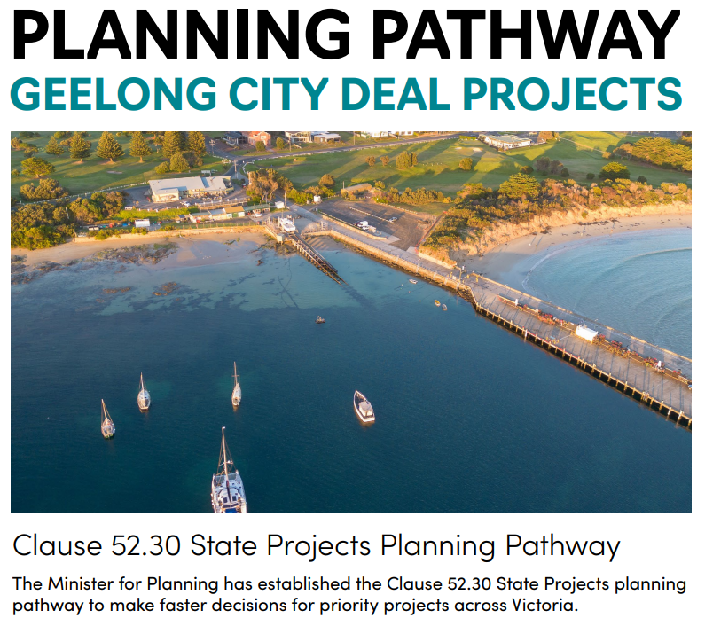
Find out more about the planning pathway for Point Grey
Planning Pathway 52:30
We are committed to keeping you informed and involved throughout Point Grey’s Redevelopment. Your feedback has already shaped the final Urban Design Framework, and we will continue sharing updates and answering questions as the project moves through detailed design. Transparency and ongoing engagement are important to ensure the redevelopment reflects both community values and legislative requirements.
How Point Grey will be assessed
Point Grey (alongside the Apollo Bay Harbour and Kennett River projects) will go through a specific planning approval process called Clause 52.30 State Projects.
What this means
- The Department of Transport and Planning will assess the project on behalf of the Minister for Planning
- All projects must still meet strict planning laws, environmental standards and community consultation requirements
- This pathway allows for timely decisions on significant regional projects while maintaining thorough assessment
Staying transparent
We believe transparency is essential. This planning pathway ensures Point Grey meets both community values and legal requirements while moving the project forward efficiently.
Want to know more?
For further information about how Clause 52.30 works for Point Grey and other Geelong City Deal projects, download the Clause 52.30 State Projects Planning Pathway Info Sheet
The Victoria’s Resilient Coast (VRC) Framework has guided the planning process for this site, supporting proactive and long-term coastal hazard risk management.
With climate change expected to increase exposure to coastal hazards—including intensified wave action, storm activity, and sea level rise—this framework provides a structured approach for assessing vulnerability and identifying appropriate adaptation responses.
The Point Grey Precinct is increasingly vulnerable to coastal erosion and inundation, with erosion hazards expected to intensify due to climate change. The current erosion hazard zone extends approximately 10 metres inland from the shoreline, with projections indicating it may reach 20 metres by 2100. While inundation risk is currently low, sea level rise is expected to affect low-lying areas from around 2070, potentially threatening key environmental, cultural, and built assets.
Adaptation planning at the site follows the Marine and Coastal Policy’s adaptation hierarchy. West of the boat ramp, minimal intervention is proposed, supported by a combination of nature-based solutions and managed retreat. Between the boat ramp and the pier, the landscape will be designed to accommodate gradual erosion. In the area surrounding and north of the pier, the existing revetment will be progressively upgraded as required. To reduce future impacts from erosion and sea level rise, all new infrastructure should be set back as far as feasible.
The VRC Framework, combined with community values and objectives, has been central to evaluating adaptation options and shaping feasible pathways.
Adaptation measures have been carefully assessed to minimise unintended impacts on surrounding environments. This process has directly informed the strategic siting of infrastructure within the precinct, enabling us to maintain the area’s core values and functions into the future.
By applying this approach, we aim to support long-term resilience and sustainable use of the site—now and beyond 2100.
If you are interested in finding out more go to the Victoria’s Resilient Coast – Adapting for 2100+ webpage.
The Urban Design Framework (UDF) is a planning document that sets out the vision for the Point Grey precinct. It provides design guidelines and requirements for built form, open space, access, heritage, and more.
How your feedback shaped the final UDF:
We listened to what the community told us, and the final UDF includes these important changes:
- Boat wash facility – Added based on your requests
- Public fish cleaning station – Included to support local fishing activities
- Flexible open space near the pier - Redesigned to accommodate community events, markets or additional parking
- Better located public facilities – Moved to be part of the new food and beverage area for convenience
- Celebrating our shared stories: Enhanced guidance on honouring the site’s rich history, including First Nations cultural connections, maritime heritage, and the timber industry stories.
What the UDF delivers for Point Grey
The Urban Design Framework (UDF) sets out the vision to revitalise Point Grey with:
- Better public access and safer pathways
- Enhanced open space for everyone to enjoy
- New facilities including a casual food venue, new Lorne Aquatic and Angling Club clubhouse and new public facilities
- Recognition and celebration of the area’s rich cultural, maritime and timber industry heritage
How the UDF works
Rather than dictating exact designs, the UDF sets out the quality, vision and aspirations of the redevelopment project. It creates a shared understanding between GORCAPA, relevant authorities, the community, Easten Maar Aboriginal Corporation (EMAC), future tenants and any other relevant stakeholders about the site’s future development.
Numerous policy documents apply to the site and have been considered in preparing this UDF.
Better access and connections
The UDF improves parking (including dedicated boat trailer spaces), creates better traffic flow, and establishes safer pedestrian pathways throughout the site. These improvements will enhance safety and strengthen the connection back to Lorne township.
Parking and traffic flow decisions are based on independent modelling available here.
Community Engagement
The Point Grey Redevelopment has been shaped by a comprehensive and staged engagement program, designed to understand community values and test ideas as the project progressed.
Engagement began with the Community Values Survey in 2024, which drew a record 1,141 responses and reaffirmed what people value most about Point Grey — its natural setting, ocean views, community facilities, and long history as a fishing hub. This was followed by the release of the Opportunities and Constraints Report, supported by a public Q&A forum, online information sessions, an explanatory video, and a local drop-in session.
In 2025, the community contributed detailed feedback during the Draft Urban Design Framework (UDF) engagement, and again during the Draft Site and Building Designs engagement, which included an online design gallery and in-person and online information sessions.
Throughout the project, the Community Reference Group (December 2023 – October 2025) played a key advisory role, offering local insights and reviewing concepts at each stage. Together, these activities created a clear and consistent picture of community priorities, directly informing the Final UDF and guiding the ongoing design work for the precinct.
Navigate through the tabs below to find out more information about how we engaged with the community.
Latest designs
Draft site & building designs
From 1–17 September 2025, we invited the community to explore the Draft Concept Designs for the Point Grey Redevelopment through our online gallery, and information sessions (both in person and online).
Draft Urban Design Framework
Thank you to everyone who shared their ideas, stories, and concerns during the Draft UDF engagement held in May-June 2025. Your input has directly shaped the Final UDF and will continue to guide the design phase.
Opportunities & Constraints
In October 2024, the Great Ocean Road Coast and Parks Authority (GORCAPA) released the Opportunities and Constraints Summary Report and accompanying Frequently Asked Questions (FAQ) as part of a rigorous master planning and design process for the precinct. The engagement included a public Q&A forum, informative video, online information sessions, and a drop-in session at the local footy stadium.
Download the summary report here.
Head Consultants NMBW Architecture Studio prepared the report in collaboration with Architecture Associates, GLAS Landscape Architecture and the Great Ocean Road Coast and Parks Authority. It was informed by a comprehensive review of Government legislation, alongside feedback from the local community, Eastern Maar Aboriginal Corporation, project stakeholders, specialist assessments, and the analysis of a range of site-specific factors.
The report outlines significant opportunities, such as the potential to:
- Celebrate the site’s maritime past and provide ongoing support to recreational angling
- Increase accessible and equitable access to the coastal edge
- Protect Eastern Maar Cultural heritage places and values
- Develop a rigorous Coastal Adaptation Plan to build resilience to coastal hazard risk; and
- Manage conflicting pedestrian and vehicle traffic
Practical issues around the safe and efficient movement of boat trailers, tourist bus drop-off and pick up points, structural integrity of the Fishing Co-Operative building, as well as appropriate car parking, bicycle use, and pedestrian accessibility will be factored into any revised design options.
Community Values
A Community Values Survey was undertaken in early 2024 to reaffirm the vision for Point Grey.
We received 1,141 responses, which set a record for our Have Your Say engagement platform.
The feedback highlighted that the precinct is loved for its natural setting; its ocean and pier views; and the community facilities it hosts.
Most respondents wanted to see the character and ‘feel’ of the site and its history as a fishing hub maintained and recognised in any future development.
Community Reference Group
The Point Grey Community Reference Group (CRG) played an important advisory role throughout the project, providing local insight and community perspectives to help shape key design and engagement outcomes. The group brought together representatives from local organisations, user groups, and residents with a strong connection to Lorne and its coastline.
Meeting regularly during the planning and design stages (December 2023 - October 2025), the CRG reviewed emerging concepts, identified issues and opportunities, and provided feedback on design principles, heritage interpretation, access, and amenity.
Their input helped ensure the project considered community values alongside balancing environmental, cultural, and recreational priorities at Point Grey.
Project location
Project Timeline: 2023 onwards
-
Timeline item 1 - complete
2023
- Final meeting of Community Co-Design Group
- New Community Reference Group formed
-
Timeline item 2 - complete
March- April 2024
- Reaffirming Community Values Survey
-
Timeline item 3 - complete
Early 2025
- CRG and key stakeholder project workshops to learn more about the precinct's opportunities and constraints
- Develop Draft UDF
-
Timeline item 4 - complete
October 2024
- Opportunites and Constraints Summary Report released.
-
Timeline item 5 - complete
Mid 2025
- The Draft Urban Design Framework open for community engagement
-
Timeline item 6 - complete
Mid 2025
- Final Urban Design Framework and Concept Designs open for community engagement
-
Timeline item 7 - incomplete
2026
Construction expected to commence in 2026.
Project Timeline: 1998 - 2022
-
Timeline item 1 - complete
1998
Lorne Coastal Action Plan recommended development options be considered for Point Grey - Lorne
-
Timeline item 2 - complete
2006
Great Ocean Road Coast Committee (GORCC) prepared a briefing paper for development opportunities and held three stakeholder and community sessions.
-
Timeline item 3 - complete
2007
Point Grey and Slaughterhouse Feasibility Study prepared by Horizon3.
-
Timeline item 4 - complete
2009
Consultants appointed to prepare masterplan involving consultation with community, stakeholders and Project Steering Group.
-
Timeline item 5 - complete
2010
Project put on hold - masterplan not progressed past draft stage.
-
Timeline item 6 - complete
2011
Community representatives lobby new GORCC Committee to resume project, leading to formation of Point Grey Precinct Agency Working Group.
-
Timeline item 7 - complete
2012 - 2014
Further community and stakeholder consultation lead to a revised Draft Point Grey Precinct Plan being released for public comment.
-
Timeline item 8 - complete
2015
Final Point Grey Precinct Plan developed, and Coastal Consent applied for and granted.
-
Timeline item 9 - complete
2017
- Architectural competition for Point Grey commenced
- Business case used for attracting City Deal funding developed
-
Timeline item 10 - complete
2018
- Architect appointed
- Initial planning application lodged
-
Timeline item 11 - complete
2019
- MACA consent granted – amended plans submitted to Surf Coast Shire
- City Deal funding confirmed
-
Timeline item 12 - complete
2020
- Surf Coast Shire councillors unanimously approve planning permit
- VCAT objection lodged
- FOI request for all consultation documents submitted by local MP
-
Timeline item 13 - complete
2021
- Creation of Community Co-design Group (CCDG)
- ECI contractor announced
-
Timeline item 14 - complete
2022
- CCDG workshops held and revised concept design for the Lorne Fishing Cooperative building developed in collaboration with CCDG
- Community engagement conducted in February - March on the community developed revised concept design
- Conclusion of Victorian Civil and Administrative Tribunal proceedings, denying a permit for the redevelopment.
Our Story
So, Who's GORCAPA?
We know, the name’s a bit of a mouthful and it can feel a little awkward introducing ourselves, but we don’t mind, because we actually love sharing our story.
GORCAPA stands for the Great Ocean Road Coast and Parks Authority. We look after the coastline, parks, and reserves along the Great Ocean Road. We love helping to protect the places you love, while making sure they can be enjoyed for generations to come.
Want to know what drives us? Check out our story to learn about our values, principles, and the role we play along this world-famous coastline.
Contact Us
If you have any questions, please contact us:
| Phone | 1300 736 533 |
|---|---|
| haveyoursay@greatoceanroadauthority.vic.gov.au | |
| Website | www.greatoceanroadauthority.vic.gov.au/ |


